West Highland Way 7 Days
Itinerary of the West Highland Way in 7 days
Embark on the West Highland Way, Scotland’s premier long-distance trail, with our comprehensive 7-day itinerary. Stretching 153 km from Milngavie to Fort William, this trail offers an unparalleled opportunity to experience Scotland’s varied landscapes—from gentle lowlands and serene lochs to rugged mountains. The journey is perfectly suited for outdoor enthusiasts seeking a rewarding challenge over one week.
The adventure begins in the charming town of Milngavie, just north of Glasgow, and concludes in the lively town of Fort William, at the base of Ben Nevis. As you walk, you’ll encounter the stunning shores of Loch Lomond, the expansive Rannoch Moor, and the dramatic vistas of Glencoe, each providing a unique backdrop from wooded paths to vast moorlands and towering mountains.
Highlights along the route include the picturesque Loch Lomond, the historical Inverlochy Castle ruins, and the awe-inspiring Glen Nevis. Outonome.com supports trekkers with detailed planning resources such as itinerary-specific pages, interactive maps, and a unique Planning Tool. These resources ensure you are well-equipped for each segment of your journey, making your exploration of the West Highland Way both memorable and manageable. Visit our outdoor maps page for detailed maps of the entire United Kingdom, enhancing your hiking preparation.
152.95 km
Medium
7 days
551 m
4402 m
4438 m
Thanks to our Itinerary Planning Tool, you’ll have no trouble planning your 7-day West Highland Way itinerary!
Steps West Highland Way in 7 days
-
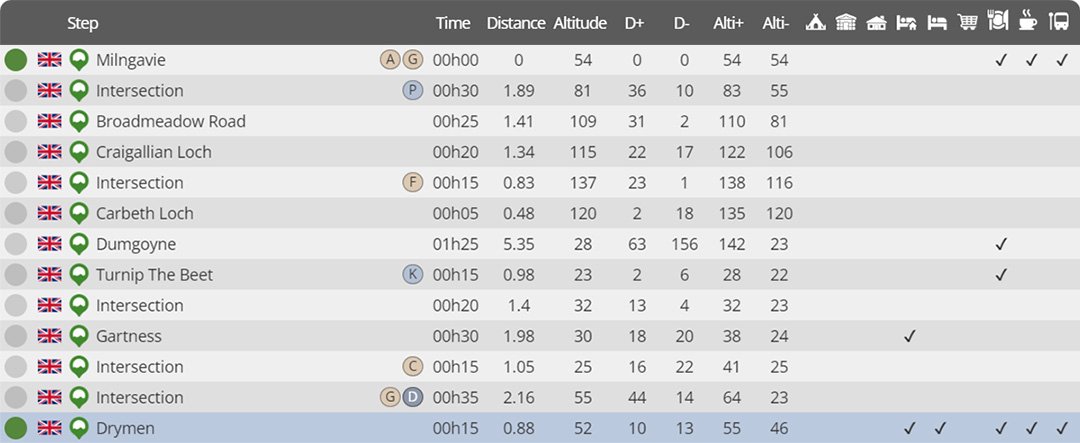
Day 1 : Milngavie to Drymen
Distance : 19.75 km
Estimated walking time : 05h10
Elevation gain : 280 meters
Elevation loss : 283 meters
Highest altitude : 142 meters
Lowest altitude : 22 meters
Steps reached : Milngavie, Broadmeadow Road, Craigallian Loch, Carbeth Loch, Dumgoyne, Turnip The Beet, Gartness, Drymen
Country crossed : United Kingdom
-
Day 2 : Drymen to Rowardennan (north)
Distance : 25.24 km
Estimated walking time : 07h50
Elevation gain : 732 meters
Elevation loss : 758 meters
Highest altitude : 335 meters
Lowest altitude : 9 meters
Steps reached : Drymen, Balmaha, Cashel, Sallochy, Lochan Maoil Dhuinne, Rowardennan (south), Rowardennan (north)
Country crossed : United Kingdom
-
Day 3 : Rowardennan (north) to Beinglas
Distance : 21.32 km
Estimated walking time : 06h50
Elevation gain : 709 meters
Elevation loss : 710 meters
Highest altitude : 102 meters
Lowest altitude : 9 meters
Steps reached : Rowardennan (north), Rowchoish, Inversnaid, Doune Byre, Ardleish, Beinglas
Country crossed : United Kingdom
-
Day 4 : Beinglas to Tyndrum Lower
Distance : 18.63 km
Estimated walking time : 06h00
Elevation gain : 648 meters
Elevation loss : 438 meters
Highest altitude : 360 meters
Lowest altitude : 21 meters
Steps reached : Beinglas, Ewich Guest House, Kirkton, Auchtertyre, Tyndrum Lower
Country crossed : United Kingdom
-
Day 5 : Tyndrum Lower to Kingshouse
Distance : 30.50 km
Estimated walking time : 08h50
Elevation gain : 671 meters
Elevation loss : 659 meters
Highest altitude : 449 meters
Lowest altitude : 54 meters
Steps reached : Tyndrum Lower, Tyndrum, Crom Allt, Bridge of Orchy, Mam Carraigh, Inveroran, Kingshouse
Country crossed : United Kingdom
-
Day 6 : Kingshouse to Kinlochleven
Distance : 14.23 km
Estimated walking time : 04h50
Elevation gain : 475 meters
Elevation loss : 712 meters
Highest altitude : 551 meters
Lowest altitude : 10 meters
Steps reached : Kingshouse, Altnafeadh, Kinlochleven
Country crossed : United Kingdom
-
Day 7 : Kinlochleven to Fort William
Distance : 24.62 km
Estimated walking time : 08h25
Elevation gain : 897 meters
Elevation loss : 889 meters
Highest altitude : 335 meters
Lowest altitude : 7 meters
Steps reached : Kinlochleven, Lairifmor, Glen Nevis, Fort William
Country crossed : United Kingdom
Would you like to discover other itineraries around the world ?


