Stubaier Höhenweg 4 Days
Itinerary of the Stubaier Höhenweg in 4 days
Discover the Stubaier Höhenweg, an exhilarating 76-kilometer trek through Austria’s breathtaking Stubai Alps, designed to be completed over 4 days. This high-altitude trail offers a perfect blend of challenging paths, serene alpine meadows, and stunning mountain vistas, making it an ideal choice for experienced hikers. Throughout this journey, you’ll encounter dramatic landscapes and diverse flora and fauna, providing a continuously captivating experience.
Starting at Kreuzjoch and ending at Elferhütte, the trail seamlessly transitions from one scenic highlight to another. Hikers will traverse towering peaks, peaceful valleys, and shimmering glaciers, each step revealing a new and breathtaking sight—from lush green pastures to rugged rocky heights. Every day of the trek offers fresh and unforgettable scenery.
Key highlights of the Stubaier Höhenweg include serene alpine lakes, quaint mountain huts, and magnificent summit views. For those looking to meticulously plan their adventure, Outonome.com offers detailed route descriptions, interactive maps, and comprehensive planning tools. You’ll find essential information on accommodations, food supplies, and estimated walking times between stages, ensuring a well-prepared and enjoyable hiking experience.
From the tranquil beauty of alpine meadows to the challenging allure of high-altitude trails, the Stubaier Höhenweg provides an immersive nature experience that showcases the awe-inspiring beauty of the Stubai Alps in just 4 days.
76.44 km
Hard
4 days
2880 m
7090 m
7194 m
Thanks to our Itinerary Planning Tool, you’ll have no trouble planning your 4-day Stubaier Höhenweg itinerary!
Steps Stubaier Höhenweg in 4 days
⚠️ Due to the difficulty of the Stubaier Höhenweg in 4 days, the following estimates take into account an advanced physical level, the walking speed is slightly above average ⚠️
-
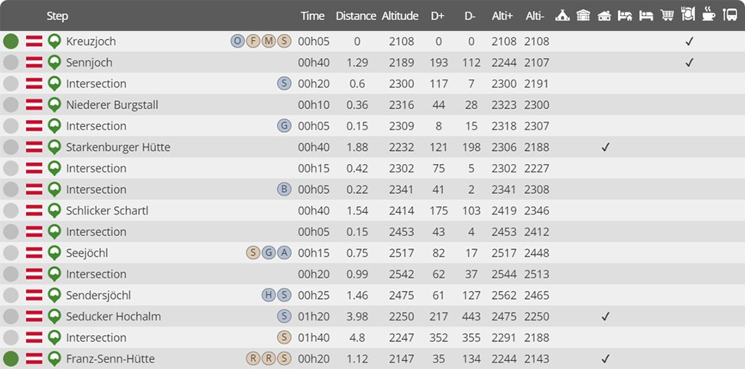
Day 1 : Kreuzjoch to Franz-Senn-Hütte
Distance : 19.70 km
Estimated walking time : 07h20
Elevation gain : 1626 meters
Elevation loss : 1587 meters
Highest altitude : 2562 meters
Lowest altitude : 2107 meters
Steps reached : Kreuzjoch, Sennjoch, Niederer Burgstall, Starkenburger Hütte, Schlicker Schartl, Seejöchl, Sendersjöchl, Seducker Hochalm, Franz-Senn-Hütte
Country crossed : Austria
-
Day 2 : Franz-Senn-Hütte to Dresdner Hütte
Distance : 22.24 km
Estimated walking time : 08h50
Elevation gain : 2070 meters
Elevation loss : 1910 meters
Highest altitude : 2880 meters
Lowest altitude : 2108 meters
Steps reached : Franz-Senn-Hütte, Schrimmennieder, Neue Regensburger Hütte, Grabagrubennieder, Mutterberger See, Egesennieder, Dresdner Hütte
Country crossed : Austria
-
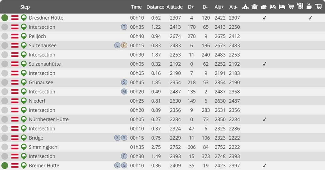
Day 3 : Dresdner Hütte to Bremer Hütte
Distance : 15.38 km
Estimated walking time : 06h45
Elevation gain : 1687 meters
Elevation loss : 1586 meters
Highest altitude : 2752 meters
Lowest altitude : 2108 meters
Steps reached : Dresdner Hütte, Peiljoch, Sulzenausee, Sulzenauhütte, Grünausee, Niederl, Nürnberger Hütte, Simmingjochl, Bremer Hütte
Country crossed : Austria
-
Day 4 : Bremer Hütte to Elferhütte
Distance : 19.12 km
Estimated walking time : 07h40
Elevation gain : 1706 meters
Elevation loss : 2111 meters
Highest altitude : 2548 meters
Lowest altitude : 1745 meters
Steps reached : Bremer Hütte, Pramarnspitze, Innsbrucker Hütte, Pinnisjoch, Karalm, Elferhütte
Country crossed : Austria
Would you like to discover other itineraries around the world ?


