Overland Track 5 Days
Itinerary of the Overland Track in 5 days
Set off on the Overland Track, a celebrated 78-kilometer hike through Tasmania’s stunning wilderness, meant to be conquered in 5 days. This legendary trail takes adventurers through the heart of the Tasmanian Wilderness World Heritage Area, showcasing some of the most picturesque landscapes Australia has to offer. The journey includes a variety of terrains, from temperate rainforests and alpine meadows to eucalyptus woodlands and rugged mountain ranges, providing a deeply immersive experience in nature.
The adventure kicks off at Ronny Creek in Cradle Mountain-Lake St Clair National Park and wraps up at Cynthia Bay. Trekkers will witness the awe-inspiring views of Cradle Mountain, the tranquil beauty of Dove Lake, and the vast plains of the Pelion region. The path includes several challenging segments, with steep climbs and descents, but the breathtaking scenery makes every effort worthwhile.
Highlights of the Overland Track include majestic waterfalls like D’Alton and Fergusson Falls, the stunning vista from Marion’s Lookout, and the crystal-clear waters of Lake Saint Clair. For a smooth and enjoyable trekking experience, Outonome.com offers detailed itinerary pages, information on campsites and huts, and customizable planning tools, along with downloadable GPX tracks. Discover the unrivaled beauty of Tasmania’s wilderness on the Overland Track, where every day unveils new, unforgettable landscapes and a profound connection to the natural world.
77.68 km
Medium
5 days
1270 m
2847 m
3006 m
Thanks to our Itinerary Planning Tool, you’ll have no trouble planning your 5-day Overland Track itinerary!
Steps Overland Track in 5 days
-
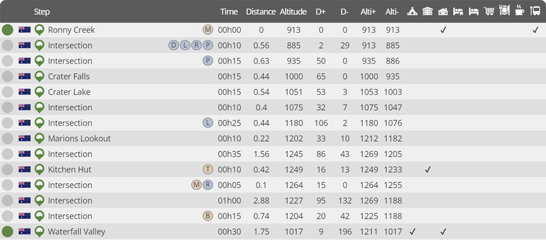
Day 1 : Ronny Creek to Waterfall Valley
Distance : 10.68 km
Estimated walking time : 04h15
Elevation gain : 582 meters
Elevation loss : 477 meters
Highest altitude : 1269 meters
Lowest altitude : 885 meters
Steps reached : Ronny Creek, Crater Falls, Crater Lake, Marions Lookout, Kitchen Hut, Waterfall Valley
Country crossed : Australia
-
Day 2 : Waterfall Valley to New Pelion
Distance : 22.46 km
Estimated walking time : 07h30
Elevation gain : 802 meters
Elevation loss : 944 meters
Highest altitude : 1109 meters
Lowest altitude : 738 meters
Steps reached : Waterfall Valley, Lake Holmes, Lake Windermere, Windermere, Lake Curran, Frog Flats, New Pelion
Country crossed : Australia
-
Day 3 : New Pelion to Du Cane Hut
Distance : 10.97 km
Estimated walking time : 03h45
Elevation gain : 439 meters
Elevation loss : 357 meters
Highest altitude : 1128 meters
Lowest altitude : 867 meters
Steps reached : New Pelion, Pelion Gap, Pinestone Valley, Kia Ora Hut, Du Cane Hut
Country crossed : Australia
-
Day 4 : Du Cane Hut to Narcissus Hut
Distance : 16.91 km
Estimated walking time : 05h05
Elevation gain : 407 meters
Elevation loss : 619 meters
Highest altitude : 1097 meters
Lowest altitude : 744 meters
Steps reached : Du Cane Hut, Du Cane Gap, Bert Nichols Hut (Windy Ridge), Narcissus Hut
Country crossed : Australia
-
Day 5 : Narcissus Hut to Cynthia Bay
Distance : 16.67 km
Estimated walking time : 05h40
Elevation gain : 617 meters
Elevation loss : 609 meters
Highest altitude : 913 meters
Lowest altitude : 740 meters
Steps reached : Narcissus Hut, Lake Saint Clair (north), Echo Point Hut, Lake Saint Clair (south), Cynthia Bay
Country crossed : Australia
Would you like to discover other itineraries around the world ?


