Laugavegur 5 Days
Itinerary of the Laugavegur in 5 days
Embark on the Laugavegur Trek, a captivating 80-kilometer journey through Iceland’s diverse landscapes, designed to be completed over 5 days. This celebrated trail showcases a vast array of stunning vistas, including geothermal hot springs, multicolored rhyolite mountains, expansive lava fields, and pristine glacial rivers. Hikers will traverse through vibrant green valleys, black sand deserts, and encounter snow-capped peaks, experiencing the raw beauty of Icelandic nature. Each day promises a new array of unforgettable scenery.
The adventure begins at Landmannalaugar, renowned for its hot springs and picturesque mountainscapes, and concludes at Skо́gar, home to the magnificent Skо́gafoss waterfall, or Thórsmörk. Detailed directions to the starting point are available further down on this page. As you journey, you will pass through the lush Thórsmörk valley, encountering stark contrasts between verdant landscapes and the rugged highlands, offering a comprehensive glimpse into Iceland’s geological and ecological diversity.
Noteworthy sites along the Laugavegur Trail include the serene Álftavatn lake, the verdant Thórsmörk valley, and majestic waterfalls like Skо́gafoss. To aid in your preparations, Outonome.com provides detailed itineraries, information on campsites, refuges, and resupply points, as well as customizable planning tools and downloadable GPX tracks for a fully immersive trekking experience.
79.18 km
Medium
5 days
1056 m
2972 m
3540 m
Thanks to our Itinerary Planning Tool, you’ll have no trouble planning your 5-day Laugavegur itinerary!
Steps Laugavegur in 5 days (Landmannalaugar to Skо́gar)
-
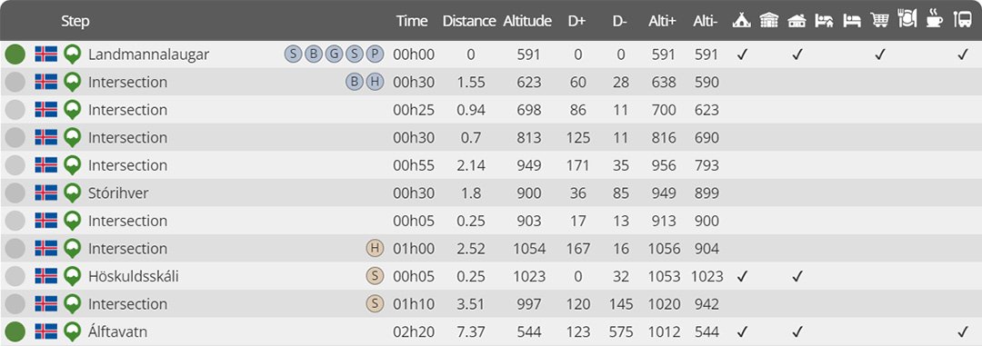
Day 1 : Landmannalugar to Álftavatn
Distance : 21.04 km
Estimated walking time : 07h30
Elevation gain : 905 meters
Elevation loss : 952 meters
Highest altitude : 1056 meters
Lowest altitude : 544 meters
Steps reached : Landmannalaugar, Stо́rihver, Höskuldsskáli, Álftavatn
Country crossed : Iceland
-
Day 2 : Álftavatn to Botnar
Distance : 16.21 km
Estimated walking time : 04h30
Elevation gain : 299 meters
Elevation loss : 371 meters
Highest altitude : 603 meters
Lowest altitude : 472 meters
Steps reached : Álftavatn, Hvanngil, Innri-Emstruá, Botnar
Country crossed : Iceland
-
Day 3 : Botnar to Langidalur
Distance : 16.05 km
Estimated walking time : 05h15
Elevation gain : 516 meters
Elevation loss : 764 meters
Highest altitude : 591 meters
Lowest altitude : 223 meters
Steps reached : Botnar, Fremri-Emstruá, Ljо́sá, Langidalur
Country crossed : Iceland
-
Day 4 : Langidalur to Baldvinsskáli
Distance : 12.98 km
Estimated walking time : 05h55
Elevation gain : 1080 meters
Elevation loss : 393 meters
Highest altitude : 1035 meters
Lowest altitude : 219 meters
Steps reached : Langidalur, Thо́rsmörk, Heljarkambur, Fimmvörðuháls, Baldvinsskáli
Country crossed : Iceland
-
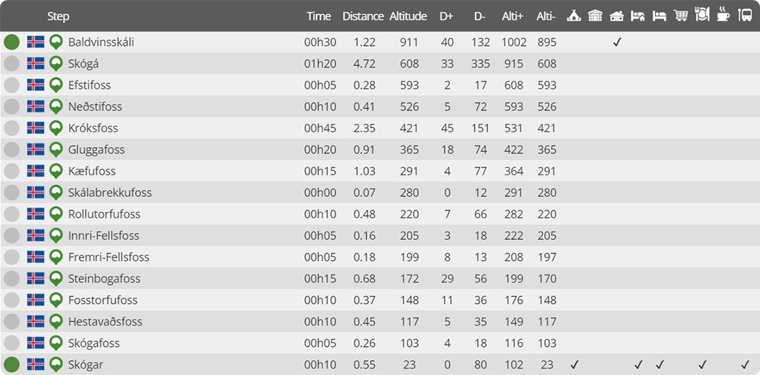
Day 5 : Baldvinsskáli to Skо́gar
Distance : 12.90 km
Estimated walking time : 04h05
Elevation gain : 172 meters
Elevation loss : 1060 meters
Highest altitude : 915 meters
Lowest altitude : 23 meters
Steps reached : Baldvinsskáli, Skо́gá, Efstifoss, Neðstifoss, Króksfoss, Gluggafoss, Kæfufoss, Skálabrekkufoss, Rollutorfufoss, Innri-Fellsfoss, Fremri-Fellsfoss, Steinbogafoss, Fosstorfufoss, Hestavaðsfoss, Skógafoss, Skо́gar
Country crossed : Iceland
Would you like to discover other itineraries around the world ?


