Laugavegur 3 Days
Itinerary of the Laugavegur in 3 days
Embark on the Laugavegur trek in Iceland, an extraordinary 3-day journey through some of the most stunning landscapes in the world. While the full route spans 80 kilometers and typically takes about 5 days, this condensed itinerary focuses on the most remarkable features. You’ll be immersed in an array of breathtaking landscapes including geothermal hot springs, multicolored rhyolite mountains, vast lava fields, and pristine glacial rivers. Hikers will explore the vivid contrast of vibrant green valleys, black sand deserts, and snow-capped peaks, each day presenting unforgettable scenery.
The adventure starts at Landmannalaugar, renowned for its naturally heated pools and vividly colored mountains, and concludes at Skо́gar or Thórsmörk, famed for the majestic Skо́gafoss waterfall. More details on accessing the starting point are available later on this page. Your trek will include the lush Thorsmork valley, capturing the lush and rugged aspects of Iceland’s terrain.
Key highlights include the serene Álftavatn lake and the dramatic vistas of Thórsmörk valley. Outonome.com supports trekkers with well-prepared plans, featuring crucial information on strategic campsites, shelters, and checkpoints, along with customizable tools and downloadable GPX tracks for a streamlined experience.
79.18 km
Medium
3 days
1056 m
2972 m
3540 m
Thanks to our Itinerary Planning Tool, you’ll have no trouble planning your 3-day Laugavegur itinerary!
Steps Laugavegur in 3 days (Landmannalaugar to Thorsmork)
-
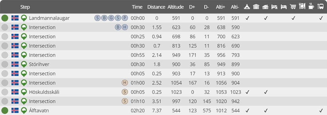
Day 1 : Landmannalugar to Álftavatn
Distance : 21.04 km
Estimated walking time : 07h30
Elevation gain : 905 meters
Elevation loss : 952 meters
Highest altitude : 1056 meters
Lowest altitude : 544 meters
Steps reached : Landmannalaugar, Stо́rihver, Höskuldsskáli, Álftavatn
Country crossed : Iceland
-
Day 2 : Álftavatn to Botnar
Distance : 16.21 km
Estimated walking time : 04h30
Elevation gain : 299 meters
Elevation loss : 371 meters
Highest altitude : 603 meters
Lowest altitude : 472 meters
Steps reached : Álftavatn, Hvanngil, Innri-Emstruá, Botnar
Country crossed : Iceland
-
Day 3 : Botnar to Thо́rsmörk
Distance : 18.56 km
Estimated walking time : 05h50
Elevation gain : 543 meters
Elevation loss : 775 meters
Highest altitude : 591 meters
Lowest altitude : 219 meters
Steps reached : Botnar, Fremri-Emstruá, Ljо́sá, Langidalur, Thо́rsmörk
Country crossed : Iceland
Steps Laugavegur in 3 days (Landmannalaugar to Skо́gar)
⚠️ Due to the difficulty of the Laugavegur in 3 days, the following estimates take into account an advanced physical level, the walking speed is slightly above average ⚠️
-
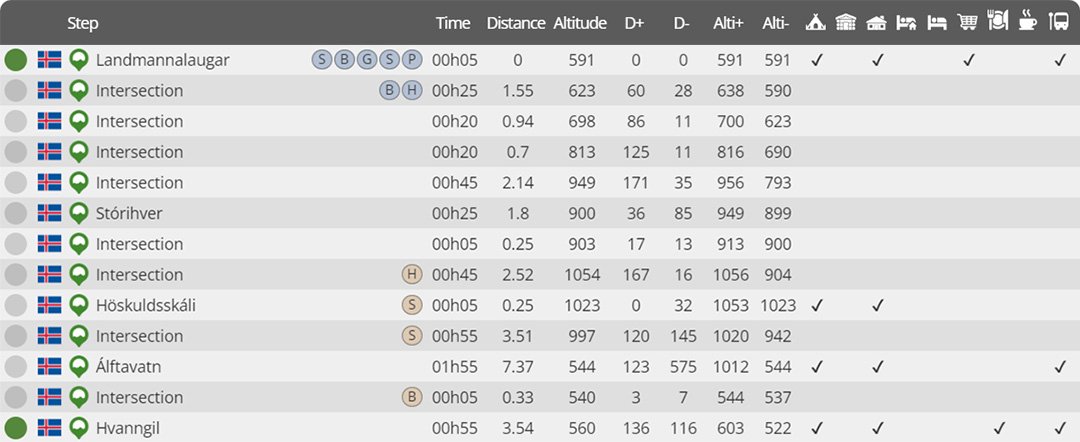
Day 1 : Landmannalugar to Hvanngil
Distance : 24.90 km
Estimated walking time : 07h00
Elevation gain : 1044 meters
Elevation loss : 1075 meters
Highest altitude : 1056 meters
Lowest altitude : 522 meters
Steps reached : Landmannalaugar, Stо́rihver, Höskuldsskáli, Álftavatn, Hvanngil
Country crossed : Iceland
-
Day 2 : Hvanngil to Thо́rsmörk
Distance : 30.90 km
Estimated walking time : 07h35
Elevation gain : 703 meters
Elevation loss : 1023 meters
Highest altitude : 591 meters
Lowest altitude : 219 meters
Steps reached : Hvanngil, Innri-Emstruá, Botnar, Fremri-Emstruá, Ljо́sá, Langidalur, Thо́rsmörk
Country crossed : Iceland
-
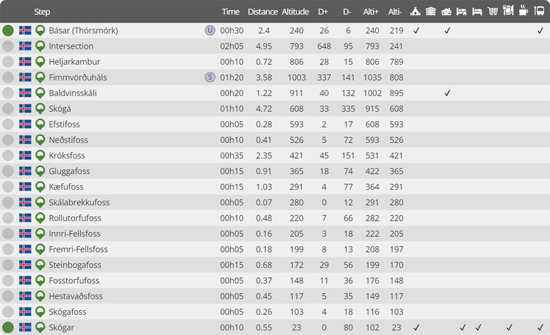
Day 3 : Thо́rsmörk to Skо́gar
Distance : 23.37 km
Estimated walking time : 07h25
Elevation gain : 1225 meters
Elevation loss : 1442 meters
Highest altitude : 1035 meters
Lowest altitude : 23 meters
Steps reached : Thо́rsmörk, Heljarkambur, Fimmvörðuháls, Baldvinsskáli, Skо́gá, Efstifoss, Neðstifoss, Króksfoss, Gluggafoss, Kæfufoss, Skálabrekkufoss, Rollutorfufoss, Innri-Fellsfoss, Fremri-Fellsfoss, Steinbogafoss, Fosstorfufoss, Hestavaðsfoss, Skógafoss, Skо́gar
Country crossed : Iceland
Would you like to discover other itineraries around the world ?


